on
John Muir Trail 2019: Week 1
Week 1: Mammoth to Bishop Pass
Day 1: Horseshoe Lake to Virginia Lake
The trek begins with a ride on a free shuttle from the village at Mammoth Lakes up to Horseshoe Lake and the Mammoth Pass trailhead. Dead trees surround the first mile of trail. According to a volunteer I spoke with soon after leaving the trailhead, this area suffers from very high concentrations of CO2. Not wanting to linger in a potentially poisonous atmosphere, I continued up the trail, reaching, McLead Lake, the first of the innumerable lakes to come.

McLeod Lake, first of many lakes along the trek
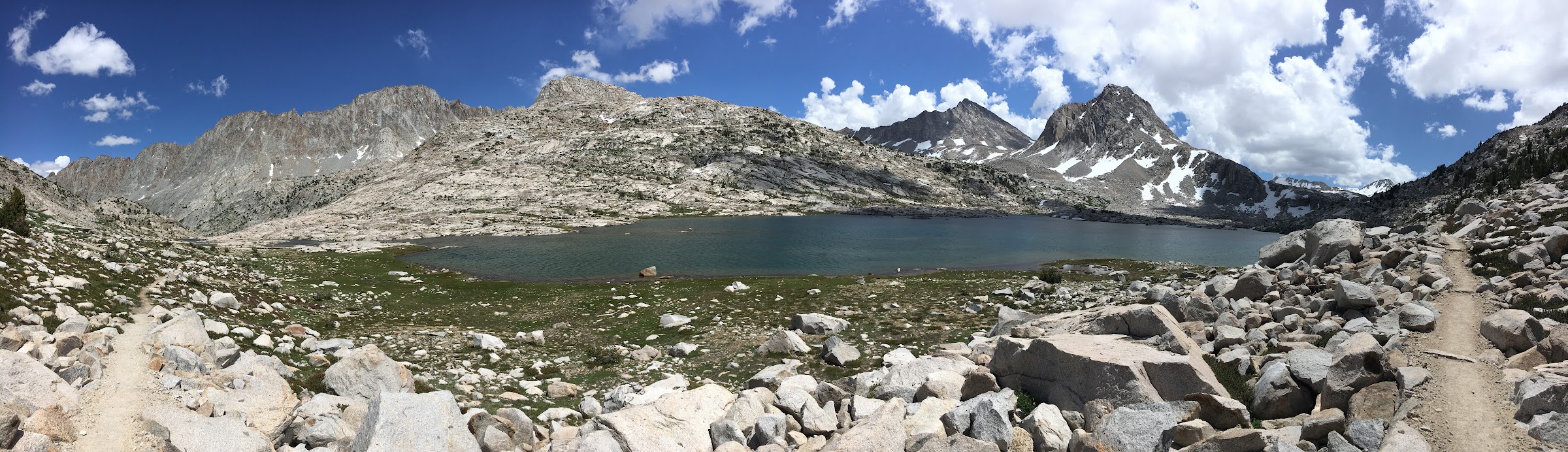
Mammoth Pass has none of the awe and spectacle of the higher pass to come along the trail. It is merely a forested saddle. Had it not been for my GPS, I’m not sure I’d have even realized that I had crossed the crest of the Sierra. I joined the main trail shortly there after and followed it up and down a few small drainages until the views started opening up to the south. The Silver Divide came into view, anchored by the massive Red and White mountain on the east end. I looked for Silver Pass, but couldn’t find it among the numerous peaks and valleys.

View south to the Silver Divide from the JMT near Purple Lake
I pressed onward, pushing for a fifteen mile day. I arrived at Lake Virginia exhausted but happy with my progress on the trail.
Day 2: Virginia Lake to Silver Pass Lake

A beautiful morning at Lake Virginia
Day Two took me steeply down from Lake Viriginia into Tulley Hole and Fish Creek. I was curious to learn what a “hole” was as I had never come across this type of place name in the Sierra. A beleagured group of hikers climbing the switchbacks gave me a foreboding sense of what was to come with their head nets and questions about how bad the mosquitos were at Lake Virigina. When I reached Fish Creek, I was swarmed. Thankfully, the long sleeves and cheap head net were enough to keep me safe from the bloodsuckers.
The climb up to Silver Pass was steady and enjoyable. I did not carry any snow gear, so I welcomed the minimal amount of snow on the top of the pass proper. I arrived at Silver Pass Lake shortly after noon and made camp on a ridge with a great view. My goal for the afternoon was a climb of nearby Mount Izaak Walton. The route took me off trail, crossing through a beautiful, gentle basin to the southwest of the peak. I climbed a loose talus face and arrived on the summit to a stunning view south to the Seven Gables and Selden Pass area.

Summit view south from Mount Izaak Walton
Day 3: Silver Pass Lake to Bear Creek
I loved the start of Day Three. From Silver Pass Lake, the trail descends alongside an amazing stretch of granite with Silver Pass Creek cascading down thousands of feet to meet the North Fork of Mono Creek. I donned my creek crossing shoes for the first time along this stretch, opting to wade across Mono Creek instead of attempt a sketchy log balance. The trail was busier here, with many hikers coming and going to Vermillion Valley Resort. Not me though; my path took up the seemingly endless switchbacks of Bear Ridge in a hot afternoon sun. The trail is not very high here, staying below 9000 feet for most of the climb through a sparse forest. I grew a bit despondent at the length of the climb, but thankfully reached the crest of the ridge which restored my spirits.
Unlike Silver Pass the day before, this was merely a ridgetop and didn’t have the views and feeling of accomplishment that crossing a pass yields. Neverless, I was happy to have reached the top and continued along the trail, aiming to reach Bear Creek proper.
My feet ached and my shoulders were sore; Day Three was the strangely the most difficult for me on the entire length of the trail. I was no longer fresh, but I had yet to gain my trail legs. Though I had intended to reach the crossing of Bear Creek on this day, I chose to make camp much earlier, right where the JMT reaches the shores of Bear Creek. The creek was very big where I camped and I wondered how difficult the crossing the next day would be as I relaxed in the afternoon sun.

Camp along Bear Creek
Day 4: Bear Creek to Sallie Keyes Lake
I awoke sore and tired from the long climb up Bear Ridge the day before. At home, I had thought that Day Four would be the day to climb Seven Gables, but having seen snow high on the peak from the summit of Mount Izaak Walton and being tired from the first three days, I decided to just press on towards Selden Pass, perhaps climbing Mount Senger from the north side.
Crossing the Hilgard Fork of Bear Creek was the first challenge of the day. There was no log bridge, but it was slow, and I made quick work of it with my creek shoes. From there it was a short walk to the crossing of the main stem of Bear Creek. The water here was higher and there was again no obvious crossing. It was far from the raging torrent I had been picturing in my mind though, and I was quickly across.
From the crossing the trail wound its way up past the stunning Marie Lakes. Islands speckle these stunning alpine lakes. I had not heard much about this area and I was absolutely blown away by the peacefulness of the scenery. Making my way up towards Selden Pass, I took in the route up the northwest face of Mount Senger. A lot of late season snow lingered on the granite slabs. It may have been passable, but I chose to skip the climb and instead went over Selden Pass and down to Sallie Keyes Lake.

Looking back on Marie Lakes from near Selden Pass
Day 5: Sallie Keyes Lake to Goddard Canyon
On the morning of Day Five, I climbed Mount Senger. A “mere” two thousand feet up from camp over mostly Class 1 terrain, I reached the summit shortly after 8am. The register was from 1978! There was a swell view back to Marie Lakes, Selden Pass, and the Bear Creek drainage as well as south towards the Evolution Basin and east into the Humphreys Basin. While descending Mount Senger, the clouds opened briefly and treated me to a ten minute hailstorm. This was the only precipitation I experienced in the whole course of my thru-hike.

View north from atop Mount Senger
From camp, I headed down, down, down towards the San Joaquin River. Along the way, I passed a group of fresh-looking people on horseback; I was nearing Muir Trail Ranch and the edge of civilization. An hour later, I arrived at MTR, anxious to pick up my food and continue on the trail. Muir Trail Ranch was not as big as I expected, and thru-hikers dominated the area when I arrived. Like most people, I had shipped myself way too much food in my bucket and I ended up dumping a great deal of oatmeal, sunscreen, and other various things in the public food buckets. Even after shedding a lot of my resupply, I was still forced to repackage all of my food and squish it down to get everything into the bear canister.

Hunger hikers scavenging from the public buckets at Muir Trail Ranch
From Muir Trail Ranch I traveled up the canyon of the San Joaquin, crossing into Kings Canyon National Park. I passed by some beautiful but busy campsites near the bridge across the San Joaquin, eventually setting up camp near the mouth of Goddard Canyon. It was a long but rewarding day.
Day 6: Goddard Canyon to Wanda Lake
After a steep, early morning climb from the San Joaquin, I found myself in idyllic Evolution Valley. Here, I had to cross Evolution Creek, another notorious crossing on the John Muir Trail. While both higher and wider than Bear Creek, I had no trouble with the simple, knee-deep wade across. From the crossing, the trail heads east past miles of beautiful meadows, before ascending a steep headwall up to the high Evolution Basin. I had heard rumor of the beauty of Evolution Basin. It drastically surpassed my expectation. From seeing a bald eagle flying above Evolution Lake, to the wide open expanse of Sapphire Lake, to the stark exposure of Wanda Lake, I fell in love with this area immediately.

Stunning Evolution Lake and the view south to the Goddard Divide
I made camp just north of Wanda Lake in one of just a few flat areas in this high alpine basin. Soon after I had set up everything, a group of four backpackers made their way up looking for a spot to camp. I offered the additional spaces near me and we got to talking. They were on a four day loop out of Muir Trail Ranch up and over the cross-country divide between Wanda Lake and Davis Lake just to the north of Mount Goddard. This trip was to be a warm-up for their High Sierra Trail hike later this summmer; I think it may have been harder than the entire HST!
Mount Huxley towering above Sapphire Lake in the Evolution Basin
My plan for the next day was to climb Mount Goddard via Starr’s Route, so we exchanged beta about the area as we took in the imposing north face of the Goddard Divide. According to Secor, Starr’s Route is supposed to be an “interesting” class 2 ledge system from a subpeak east of the summit up to the crest of the divide. I believed I could see this ledge from camp and it looked free of snow, but getting up to that level looked tricky… and it turned out to be just that!
Day 7: Wanda Lake to Helen Lake
I awoke early, anxious to begin my ascent of Mount Goddard. From camp, I climbed easy, grassy slopes up to the divide with Davis Lakes. At the top, I was confronted with a large boulder field. I had intended to contour around to the base of the north ridge up to the main Goddard Divide, but the tedium of the loose talus and boulders forced me to lose a few hundred feet of altitude before continuing south.
North Face Mount Goddard and Davis Lakes
At the base of the north ridge, things became more interesting. My route description essentially said to “climb the north ridge” and not much more, so I made my way up a hundred feet or so of ever steeper snow. At the upper reaches of the snowfield, I had to kick steps into the snow to gain purchase on the icy surface layer. An ice axe and crampons would have made this stretch easy, but alas, I had neither.
At the top of the snowfield there was an awkward step across from the top of the snow to get onto the rock. Not a good place to fall. Once on the rock, I took a rest and surveyed my route ahead. What should have been “easy class 2” was instead a stiff class 3 climb with freezing holds and the aforementioned exposure to the hole at the edge of the snowfield. I climbed maybe ten feet up before getting spoked and re-evalutating my options. I tried a few other lines; none of them were any better. Confused, I made my way back down the snow to see if I had somehow missed the route.
Looking back up, it did appear that I could climb about a third of the way up the ridge height on a gentler gully to the west and then connect back onto the ridge. Unfortunately this whole area was in the shade and covered with steep, icy snow. It was then that I knew this climb wasn’t meant to be. Without skill on class 3 rock, proper snow tools, or a partner, I was unwilling to take on the risk of this type of a climb this far into the backcountry.
Dejected, but not tired, I made my way back to camp, seeking to salvage the day with an easier climb nearby. I packed up camp and motored up the trail, passing a number of parties on the way up to Muir Pass. I had seen many photos of the Muir Hut, and it was just as cool as I had hoped. Nestled on the saddle at the pass proper, it looks back down onto the lakes of the upper Evolution Basin as well as southeast towards LeConte canyon and the Palisades.

Muir Hut at Muir Pass
My route led me off-trail from the pass, over a suprisingly deep, snow-covered basin towards Black Giant Pass. This gentle pass marks the boundary from the heavily traveled LeConte Canyon area and the trail-less and wild Ionian Basin. My target was Black Giant, a 13000 foot peak. Supposedly class 1 from Black Giant Pass proper, I took a steeper class 2 route from near the lake north of the pass. This was the highest I had thus been on the trip, and after my earlier misadventure in the morning, I was definitely feeling it.
After struggling up to the summit, I was treated with a magnificient, 360 degree view. Secor describes the view as “swell”, as did many snide commenters in the register. From the summit, one can look down on the miniscule Muir Pass two thousand feet below, Mount Goddard across to the west, the majesty of the Ionian Basin peaks, and the huge, imposing Palisade range to the east. This is one of the best summit views I’ve had the privilege of experiencing in the Sierra.

The Palisades and Dusy Basin from the summit of Black Giant
Camp was a few miles down the John Muir Trail, through a stretch with on other campers, above the shores of Helen Lake.
Day 8: Helen Lake to LeConte Canyon
I awoke to a frozen water bottle and a crystal clear morning. Looking to take an easy day, I decided against climbing nearby Mount Fiske, and instead packed up and headed down-canyon.

Mount Fiske above Helen Lake on a freezing morning
The JMT descends into LeConte Canyon quickly, losing elevation as it passes a series of cascades and waterfalls. I was thankful to be passing through this stretch after the snow had mostly melted, as it looked like it would be tricky to follow the trail when buried under snow.
After a few hours of easy walking I reached the junction with the Bishop Pass trail and set up camp just past the LeConte Ranger Station. An easy afternoon along the Middle Fork of the Kings River turned into an early dinner. As I was eating, I looked up and about 50 yards distant noticed a large, moving, black mass. As it turned towards me, it became clear that this was, in fact, a bear. At the time I had literally all of my food out of my bear can and an aromatic bag of food open. Though packing the bear canister had always seemed difficult prior to this point, I managed to repack everything in about ten seconds. Thankfully the bear was more interested in turning over rocks (looking for insects?) than in my food, and he soon meandered off.
I slept poorly that night, wondering how much protection the thin nylon of my tent would give me against a bear interested in a midnight snack.
comments powered by Disqus